File:Groom Lake and Papoose Lake.jpg
Jump to navigation
Jump to search

Size of this preview: 800 × 452 pixels. Other resolutions: 320 × 181 pixels | 640 × 361 pixels | 1,024 × 578 pixels | 1,280 × 723 pixels | 2,560 × 1,446 pixels | 4,368 × 2,467 pixels.
Original file (4,368 × 2,467 pixels, file size: 9.65 MB, MIME type: image/jpeg)
Summary
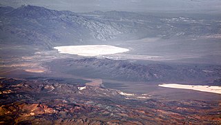
| Description | Groom Lake and Papoose Lake, both in the Nevada Test and Training Range. Groom Lake is also in Area 51. Note that some of the lines you see beside Groom lake are among the longest runways on Earth. |
| Date | |
| Source |
|
| Author | Doc Searls from Santa Barbara, USA |
| Camera location | | View this and other nearby images on: OpenStreetMap |
|---|
Licensing
This file is licensed under the Creative Commons Attribution 2.0 Generic license.
- You are free:
- to share – to copy, distribute and transmit the work
- to remix – to adapt the work
- Under the following conditions:
- attribution – You must give appropriate credit, provide a link to the license, and indicate if changes were made. You may do so in any reasonable manner, but not in any way that suggests the licensor endorses you or your use.
| This image, originally posted to Flickr, was reviewed on October 13, 2010 by the administrator or reviewer File Upload Bot (Magnus Manske), who confirmed that it was available on Flickr under the stated license on that date. |
File history
Click on a date/time to view the file as it appeared at that time.
| Date/Time | Thumbnail | Dimensions | User | Comment | |
|---|---|---|---|---|---|
| current | 12:31, 27 June 2017 | | 4,368 × 2,467 (9.65 MB) | wikimediacommons>Ralf Roletschek | falscher Farbraum, Blaustich |
File usage
The following page uses this file: